The Western Pir Panjals- Finding Lost himalayan Trails of Rajouri
"Legacy of our Forefathers, we ought to carry
generation to generation we preserve this aerie"
It wasn't supposed to be an unusual day until I re-installed my Google Earth to explore the untouched depths of glaciers. Every login to this application has something new to show with adding number of stunning photographs of untouched and new explorations high and deep in Himalayas mostly uploaded through an online photography platform called Panoramia. I feel good to see the rising popularity for hiking in our country among all age groups.
"When the black smoke rises, people rush to mountains"
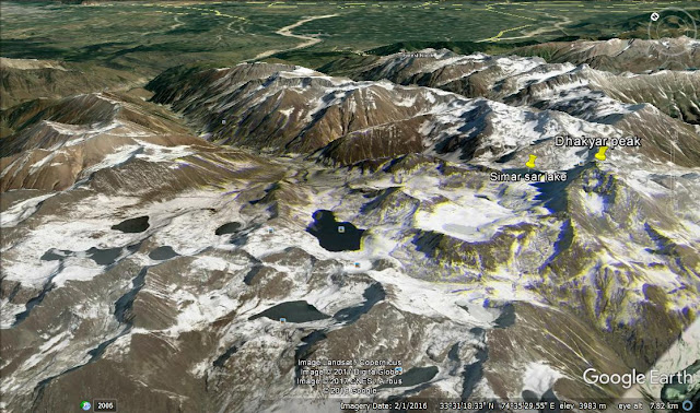
Scrolling my mouse like a helicopter in the satellite map, probably trying to revise my knowledge of every Himalayan Sub Range I had seen I came across a thin white line drawn by mother nature from NW-SE beginning somewhere near LOC around Poonch area with beautiful Turquoise Tarns and pyramid shaped peaks and what more I needed in a Sleepy summer afternoon to keep me awake. This was enough to boost my adernaline. I was almost on the verge of breaking my screen to enter those beautiful plateaus covered with snow.
 |
| Western Pir Panjals - The plains in Background are Kashmir valley (Shopian) |
Wondered I, What sub range is this, as I had not seen it earlier on my map or probably I had been too lazy to hover my helicopter mouse over this area. I felt amused on scrolling deep trying to zoom in those snow capped mountains that it was none other than the Western Pir Panjals seperating Kashmir and Jammu.
Pir panjals is a Mighty range in Himalayas beginning from Kullu valley (Centre of himachal) and continuing taking left and right turns in a snake like pattern into J&K creating many sub ranges.
Why haven't I scrolled into this region earlier, I asked myself only to realize that I have been lazy and crazy enough to study the peaks that are too common a man knows and setting aside these less ventured areas.
 |
| Picture Credits - Google Images (A free platform for all images) |
The Search Begins :
Spending hours crawling like a spider on Google to find every possible information all I could find was a Government run website to promote tourism in Rajouri and a few photographs of which most of them were clicked by only one person. The website had a brief description of dozen of multi day treks covering passes to enter Kashmir valley and few routes to those Glacial tarns that I had seen from my helicopter mouse click a few hours back.
Increasing curiosity and uncontrollable 'me' I spent few more hours on zukerbergs public portal (FB) again to be disappointed only to find a few dozen of photos of these snow covered peaks and none with a close view.
Close to Reality :
The best Source to satisfy my unsatisfied thirst for my new exploration was to call a local hiking club at Rajouri who had uploaded all those photos only to again be disappointed by their words.
The old Gentleman on phone was founder of 'Everest Club, Rajouri' who had spent a major part of his lifetime in that town. After having expressed my desire to explore these less known trails in his hometown all he could tell me was to forget about what I had been doing from past five hours and focus on some much explored (commercialized) trails. Some of which he mentioned was attempting Mount Deo Tibba Instead. Deo Tibba a near 20,000 feet Mountain was no match for these short treks. Anyways I thought it wise to ignore this comment.
Few highlights of our conversation-
- There haven't been any expeditions on any of those peaks since past twenty years due to rising terrorism in mid 90's.
- The Government has not been supportive in establishing these routes
- The peaks are semi-technical and mostly below 5000 meters which may provide a sheer climbing experience to beginners.
- The crossing of those passes connecting Rajouri and Kashmir are very unusual even among shepards.
- I won't find any guide in whole district who can take me to those beautiful lakes
- Absolute lack of support and basic facilities.
- Unsafe and terror motivated area
To be frank, dear readers, It had hurt a hikers sentiments, but being respectful to an experienced local I thought it wise to embed these words in my mind very clearly. After a discussion on various treks we both had attempted he concluded that the day isn't far when this district will be flooded with groups of hikers. I feel it shall take five more years as the authorities themselves seem less confident on their claim.
Expedition Planned this year by Rajouri development Authority :
Another contact I found was of Rajouri development authority and despite of being a public holiday I called at the number mentioned on their site to receive a response I had been waiting for. The guy at the the other end repeated the words of Founder of Everest club but assured me that they were planning an expedition to famous seven lakes in these hills and I was most welcome to join this.
Various Highlights of our Conversation :
- Reaching Base Camp (BC) is a challenge in itself due to lack of maintenance of roadheads.
- Government plans to establish these trails in a matter of two years (Well!, a similar headline I read in newspaper two years back)
- No Professional Guide available
Various Prominent Routes :
The trails, The peaks, The tarns are nothing less than heaven on Earth and same applies when you see them on your Google Earth. Having researched about these areas for a long time I plan to pay a visit and look forward to like minded enthusiasts interested to join and promote these regions. 'Everest Club' had gone to these glaciers in January, 2015 to enlighten their souls and the photographs they posted on Facebook are stunning.
The only Route so far which is open to public is Mughal Road, Connecting Rajouri to Shopian and the road is almost on the verge of completion. The route was developed by Akbar- The Great emperor during his time. This road is one of the most scenic route you will ever get to travel in India.
 |
| Pir Ki Gali Pass on Mughal road |
Some documented Trekking Routes I found are-
Base: Rajouri
Simar Sar Lake & Dhakyar Peak---
Rajouri Kandi - Kesri Hill - Kenaki Water Fall-Dada nar - Talyani - TalyaniGalli - Marguri - Bela - Simar Sar Lake - Bela Top - Dhakyar Peak - Rupri Galli Pass.
Nandan Sar Lake--
Rajouri-Thannamandi-Dehra Kee Gaali - Girjan - Panjtari - Khuha Gum Sar - Nandan Pass - Nandan Sar Lake and 6 Other Lakes - Jaldi - Aliabad - Hirpur - Srinagar.
 |
| Simar Sar Lake - (Picture credits : Google images) |
Base: Darhal
Neel Sar Lake--
Darhal - Kanda -Shaker Marg - Cha Sari - Dood Wali - Chamber - Chamchi Sar Lake - Handoo Pass - Bhagh Sar - Sarota Valley of Flower - Neel Sar - Panjtari- Girjin - Noori Chamb - Bheram Galla - and Back to Rajouri.
 |
| Neel Sar Lake - (Picture credits : Google images_) |
Base: Budhal
Budhal - Saveri Marg - Khodra - Simar Sar Lake - Bella - Kotoria Sar Lake - Dhakyar Peak
Base: Rajouri
Rajouri - Budhal - Sar sot - Reta Wali - Harshou - Goray wan - Parhi Wali Marg- Konsar nag lake - Mahinag - Kungwattan - Aharbal (water fall) - Srinagar. (This route is Frequented by locals of Srinagar upto Konsar Nag)
 |
| Konsar Lake |
Base: Thannamandi
Thannamandi - Noori Chanbv - Chandi Marh - Poshina - Bagla - pir Pass - Aliabad - Mirpur - Suphian - Srinagar.
Choti Thannamandi - Chandi Marh - Kabar Pathran - Bagla - Ganga Choti - Choti Marg - Choti Galli Pass - Kundhlan - Yous Marg - Srinagar.
Base: Rajouri
Rajouri girjan - Panjtari - Khuya - Sarota - Shaker Marg -Roopri Pass Bela - Khodra - Budhal.
Prominent Peaks-
- TataKuti Peak (4725 m) in Poonch
- Dhaykar Peak (4592 m)

Dhakyar Peak Winter edition - (Picture credits- Google images) - Chor Panchal Peaks (4315 m)
- Sunset Peaks (4669 m),
- Chandan Peaks (4564 m),
- Kajalana Peaks (4207 m)
Tata Kutti is the highest peak in the Pir Panjal Range which is (4725m) above the sea level. This peak was once climbed by a foreign trekker Erenest F Neve on 09 August, 1910. Similarly the other important peaks in this range are still waiting for the climbers.
Some trekking parties of this area made a number of attempts to climb this highest peak but due to non-availability of infrastructural facilities and in absence of proper equipment for climbing they could not reach the top of the this peak and do much in this field.
I hope this would serve a platform to promote this untouched heaven...


Comments
Post a Comment